
A Cradle of Industrial Development.
Alan Hayward
Source: Neath Antiquarian Society
Neath Antiquarian Society Transactions 1995-96.
The Name
Traditionally the name is said to derive from St. Paul, who was reputed to have preached from the ridge of the Graig, following his journey to these western shores, when he was supposed to have landed at Briton Ferry, also known as Llansawel (Saul’s Church). Confirmation of this story was said to lie in there being another Craig-y-Pal at Glais in the Swansea Valley, a place also supposedly visited by him.
Welsh place-names are invariably highly descriptive of their surrounding landscape features. One version for Llansawel is given as the Church under the breeze, an apt interpretation for St. Mary’s Church location. While ‘Craig’ readily translates as a ‘Rock’ or ‘Cliff, the affix ‘Pal’ is obscure and perplexing.
The historian D.R. Phillips gives the sea-bird Puffin as a meaning, but as both sites are well inland this does not seem feasible. Others too, such as Phillip Morgan a 19th century writer, and the Rev. Dr. Walters of Llansamlet, in his Parish magazine of July 1891 avow that the St. Paul’s local associations are true.
However, the most thought provoking research on the subject lies in an intriguing article written for the Glamorgan Illustrated Magazine’ of 1951 by Miss Picton-Turberville, M.P. Therein she cites the testimonies of a number of Biblical scholars from the earliest times to the present.
She states “I am well aware that there is no evidence that St. Paul was ever in Wales.
I have collected all that I can find that would have made it possible, but present this still as a legend, the truth of which would have made it possible at least shown to be within the bounds of possibility. There is nothing to make his visit incredible. If there is no clear evidence, there is nothing decisive against it.
Four missionary journeys made up to A.D.63 by the Saint are known but from that date until A.D.67/68 the accepted time of his martyrdom, his movements are enveloped in mystery. Miss Picton-Turnberville comments “was it not likely that during those few last years he fulfilled his declared intention to travel to Spain (Romans 15, v. 24), from where he might easily have gone to South Wales”.
References are made to the definite statements of St. Clement of Rome in A.D.75, Theodoret Bishop of Cyrhus in the 5th century, and that of St. Jerome and others all learned men who believed he had travelled to the limit of the west, which included Britain. Wishful thinking, a myth, or indeed a glimmer of the very truth, the story remains an enigma.
There is yet another alternative in that ‘Pal’ could be albeit tenuously, linked with ‘Y Dwmbal’, a large elongated sandbank island that existed in the river Neath for long in the 18th and part 19th centuries in the large ‘S’ bend below Pentreffynnon.
This backwash strip split the main stream creating at various tidal conditions a veritable helter-skelter race (dwmbwl-dambal). Samuel Hosgood’s map of 1832 clearly shows the dangerous state of the river at that time.
The Farm
Set in the heartland of old ‘Scuan’s hilly district, an accurate picture is shown on how it looked in 1770-71, in a survey of the Neath Abbey Estate made by John Davies, for the ‘Lords of the Abbey’.
Comprising 137 acres in extent, its field structure formed a long strip of territory, part ‘Morfa’ (salt-marsh), part ‘Graig’, (the rocky slope on whose summit the farmhouse stood at about 200 ft. O.D.), part ‘cae glas’ (grass meadowland), and part boggy wetlands on the slope of ‘Gwern-y-Scuan’ (lower Skewen), together with small clusters of woodland.
It was tenanted by the widow Jane Williams, and its boundaries abutted on to Gwern Andrew Farm westward, while to the north and north-east its lands touched parts of Pen-yr-Alley and Pen-rhiw-y-Scuan Farms, (now Skewen Park).
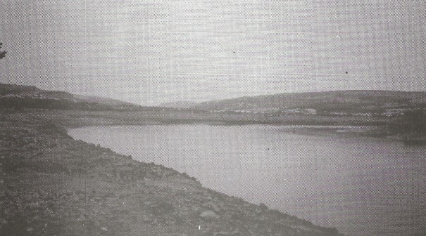
Initially Craig-y-Pal possessed an idyllic setting, commanding from its elevated ridge a remarkable field of vision overlooking the estuarial tidal saltings, and stretching from Coed-yr-Iarll at Earlswood, to well inland up the valley trench to beyond Tonna.
Precisely when Craig y Pal became a farm is not known, but it appears to be around the late 17th century, and it is known that it had a school in existence in 1740, described in the itinerary of Howel Harris, a pioneer of the Methodist movement in Wales, and a visitor to the Circulating Schools established in the district by the Rev. Griffith Jones of Llanddowror.
The progressive changes wrought on Craig-y-Pal Farm
Its rustic tranquility was soon to be shattered, and dramatically transformed from early on, particularly on its Morfa land, which was no more that half-a-mile wide between the foot of the Graig and the river Neath.
Over this area flowed an almost continuous movement of commerce carried either on the artery of the river, or by canal, tramroads, railways, and road, all in such close proximity that they jostled for space within this narrow corridor.
Such a concentration of various modes of transport would rarely be seen elsewhere in South Wales even in its congested valleys.
From the height of the Craig one could stand and marvel at the spectacle below always giving a fascinating picture, ever changing, and hardly ever stopping except at times of acute industrial distress.
Today the automobile is the dominant form, and an endless restlessness of motor traffic surges along the valley floor, likened to a disturbed ant hill.
On a very broad based canvas this article attempts to capture some aspects of the significant changes which this Farm underwent and endured before it succumbed in the name of progress; and its last vestiges of fields swallowed in large bites to total obliteration by massive housing development in modern times.
The River and early Shipping
Leland visiting this valley in 1536/8 observed that there was considerable activity in coal works and shipping. By about 1660 the Mines Royal Society had vacated their pioneer site, founded in 1584, at Aberdulais, and relocated their Copper Smelting Works at Neath Abbey, on the right bank of the Clydach tributary very near its confluence with the river Neath.
A probable reason for this move was the better river access, avoiding the navigational problems leading to the upper river reaches, caused by an old monastic weir at Melincryddan, and the large sand-island hazard already referred to, at Pentreffynnon.
The key resources, coal for fuel, and water from running streams as a source of power for driving machinery were abundantly available in the district, moreover the sea journey from Cornish ports was relatively short. These attractive features stimulated the interest of English entrepreneurs, and after Acts of Parliament abolished the restrictive rights of the Mines Royal Society, the way was opened for other industrialists to become involved in the Copper industry, and introduce new methods of production.
A strong dual trade developed between Cornwall and the river Neath area, copper ore being imported, and returned cargoes of coal despatched for their Copper and Tin mines. The earliest reference to this trade was given in Welsh Port Books, that in 1585 a John Bwaple (master of the ship ‘Le Jesus’ of Neath) and another ship captain Thomas Reynolds who were both waiting at St. Ives to load copper ore.
During the 17th century the shipping trade of the Neath river expanded rapidly. In a Blue Book record of 1810 the coal export trade from the river to Bridgewater showed figures of 1,608 tons in 1790, 1,348 tons in 1796, and 1,446 tons in 1809. On one duty or another the river was alive with sail-craft weaving a complex pattern of freight movement and with Pilots and Hobblers adding to the general melee as tidal conditions permitted.
Because of the increasing burden on river wharfage by the first half of the 19th century serious thought was being given to improve river navigation and build a substantial Harbour float, and Docks.
To this end in 1842/3 Alfred Russell Wallace had surveyed soundings of the river between the town of Neath and the sea. Also Henry F. Palmer, F.R.S., produced a remarkably detailed scheme for the proposed Docks. By an Act of 1843 given Royal Assent the Commissioners appointed were given the right to proceed.
A tidal Lock would control water level in the ‘Float’; of 170 acres size, and work began on the project in 1874.
However, as a result of heavy storm damage in 1886, and some lack of funding the work was abandoned, leaving only relics, such as the dock masonry near Red Jacket Pill, a Pumping House on the east bank recently demolished, and the partly excavated ‘New Cut’ the latter meant to bypass the river flow from the new Docks.
If the Plan had reached maturity the disruption of the old river course might well have had serious implications for the salt marshes below Craig-y-Pal.
(a) The Red Works (Gwaith Coch)
This works was located on the north river bank below the later Crown Copper Works, and is identified in three maps dated 1757-60, 1766, and 1792, (see ‘Sources’ for details). Whether this was a ‘satellite’ undertaking of the Mines Royal Society is not known, but they certainly had an interest in that quarter, because two Dynevor Leases of the 1st of May 1795, and 1st June 1798 are concerned with the purchase of “A House and Land of 77 acres called Pal’. One may perhaps infer that at the time of this first Lease, Mrs. Jane Williams had died, and her descendants or relatives were no longer interested in the Farm.
(b) The Crown Copper Works
This Works also set on the river bank inherited the name ‘Gwaith Coch’ from its predecessor, probably derived from the fact that some stream in the vicinity carried ironstone leaching, which stained the ground a reddish-brown colour.
The first Dynevor Lease mentioning this Works was in March 1806, granting Messrs. Pritchitt, Ledsum, and Jukes land for the erection of Copperworks. Presumably these were Agents acting for the Birmingham based firm.
From that time it began to take up an extensive tract of riverside, its banks reinforced by slag from other works to prevent flooding, and to provide a quay for mooring ships.
Being labour intensive in its operations, housing settlements began to form the early growth of Skewen
The Company achieved some prominence in the period 1811-1814 by producing Copper tokens (‘tocyns’ in colloquial Welsh), which could be exchanged for goods or pay for services rendered. This was a practice sanctioned by the Government in order to make up shortage in currency because of the Napoleonic Wars, but was suppressed after 1817.
In 1837 the Neath Abbey records showed this Copperworks having 40 acres of ground, but in the following year 2,401 acres of their holding was put up for sale.
Among the property on offer was a 3 share in the Crown Works, which suggests there was some attachment of ownership between the Dynevor and Neath Abbey landowners.
Soon after the Crown Company relinquished possession, and Williams, Foster & Co. already active in the Swansea Valley took over.
It was a time when as long as British Copper ores were being brought into the river by small coastal shipping the local Works thrived, but from 1828 when foreign ores of richer quality started being imported into Swansea by large vessels to its superior docking facilities it caused the ultimate migration and concentration of the industry into that Valley.
After mid Century the site fluctuated under different owners and copper smelting here gave way to the calcining of zinc ores.
The primary use for zinc was for alloying with copper to make brass, a commodity much in demand for domestic ware and also for military purposes.
Later the process of coating sheet-iron. and steel to make a galvanised product assumed increasing importance. The Emu Spelter Works followed in time by the Neath Spelter Works (Spelter a commercial term for Zinc), were two of the last of the firms of this description to use the site.
Decline of the Copper industry which for a long period had such a strong hold on the region set in about 1870 when those countries which had their own ore supplies built their own refining plant.
Neath and Swansea Red Jacket and Junction Canals, later called the Tennant Canal
The history of this once important water course is well documented, so that it is sufficient here to focus entirely on that area local to Craig-Y-Pal Farm. Below the Graig this Canal’s directional line rums next inward to the old Crown Copper Works, and parallel to its buildings.
Here it has an average width of 30ft and a depth of 5ft, which was adequate to give passing room for two large barges, each capable of carrying between 20 to 25 tons.
Notable features on this sector included:—
Two aqueducts built over the Canal, one for the ‘Bendle’s Pond’ reservoir, and a smaller satellite Pond nearer the Works. (Bendle was presumably the Contractor). Both were supplied by a stream draining the ‘Cae Glas’ fields to the north above. Locally the position of these aqueducts was known as ‘Nant-y-Cafn (Stream in a trough).
At mid 19th century a coal loading point at a small Canal dock was used by the Dynevor Coal Company near the later G.W.R. Cardonnel Halt, (named after the landowner the Rt. Hon. Arthur de Cardonnel, 6th Baron Dynevor).
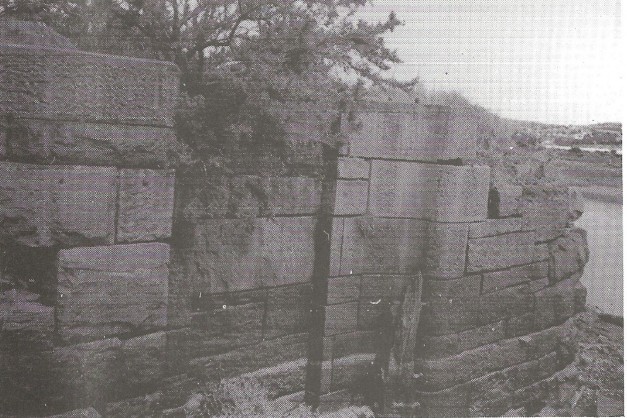
From Pont Sais bridge on the canal at Pentreffynnon, a spur branch ran to a riverside Lock with an adjacent large ponded Dock to allow turn around of barges. The Lock’s exact age is not known but it is likely that it was built soon after the Canal was opened for commercial traffic.
In the riverside here are also the remains of large posts which must have supported a loading stage for moored ships. ‘The site was probably last used by Evans & Bevan the Colliery owners of the Rhyddings, Tor-Cefn, and Gellia coal-works before they moved to the Dulais Valley.
The Lock is a magnificent example of a master masons work, having approximate dimensions of 100ft. long by 12ft. wide and 10ft. deep. Its walls are a mixture of random sized brownish coloured sandstones, some blocks being of immense sizes, but interlocking cleverly with lesser slabs.
These walls have a splendidly dressed stone finish, and the curved blocks at the gate jamb positions are extremely finely moulded. Although its wooden gates have long disintegrated this Lock, other than a small loss of stonework remains in a state of remarkable preservation.
Still on some Craig-y-Pal territory, on the Neath Abbey side of the Pont Sais bridge, William Kirkhouse, the Canal Engineer encountered serious problems with quicksand’s, when needing to make a cutting 500 yards long and 30ft deep. The difficulty was resolved by installing an inverted arch of masonry, and its location is known locally as ‘the Sands’.
Cornish and Devonshire crew members of ships calling at the Dock below Pentreffynnon took advantage of the work opportunities available in the adjacent Copperworks, and were the first to settle and create that little hamlet, a section of which took the name ‘Tai Saeson’. Many were staunch Methodists, and it was from them that the movement was imported and spread into the developing Skewen village.
Their influence inspired the building of local chapels: ‘Salem’ at Pentreffynnon in 1845, the ‘Bible Christians’ on the other corner of Brook Street in 1865, “Skewen Wesley” at the White Gates in 1878, and the ‘United Methodist’ at New Road in upper Skewen in 1909.
The Tramroad Complex
In the last decade of the 18th century, Richard Parsons an Ironmaster with Works at Clydach, and Ynyscedwyn, and who had been manufacturing iron at the Cwmfelin site in Neath Abbey, relinquished his lease in favour of a Quaker consortium of Fox, Price, and Tregelles, who had a foundry at Perran Wharf, on the Fal river at Cornwall, but wished to expand further into the iron trade, and engineering generally.
At the same time Parsons secured a lease of the Neath Abbey Estate minerals, and took over their Collieries hitherto worked by the Landowners. In the same period he leased 60 acres of saltmarsh plus the old Abbey Wharf, and by linking these diverse interests he began to form a network of tramroads, which enabled him to supply coal to the adjacent Copperworks, and the Ironworks then in the process of being built. These were shrewd moves making Parsons a leading industrialist in the district.
In 1806 the Quakers who had initially been dependent on Parsons’ coal for the Ironworks, succeeded in obtaining a lease of the minerals under the Dyffryn Estate, which gave them the liberty to control their own coal requirements.
An Agreement was formed in 1809 by them with Parsons for making a tramroad to connect their Dyffryn Colliery (Pwll Mawr) into the Parsons tramroad system, and extend this alongside the river Neath westward to a point below the Crown Copperworks, and there to erect staging for loading shipping with their coal.
This place was known afterwards as ‘The Quakers Old Bank’ and was the beginning of the laying down of a comprehensive web of tramroads over the Morfa land.
By mid-century the Dynevor Coal Co’s route from their Cwmdu and Brithdir mines ran south over the Waun at Upper Skewen then over Penyralley Farm (now Skewen Park) by incline to an embankment crossing the Cae Glas fields of Craig-y-Pal Farm and finally near that farmhouse to descend by a last incline to the Valley floor where it entered directly into the Crown Works or alternatively enabled the coal to be loaded into canal barges for destinations elsewhere.
When the Neath Abbey Iron and Coal Co’s closed in 1874, this Dynevor Co amalgamated with other small mines to form the Dynevor, Dyffryn, and Neath Abbey United Collieries Co., and utilised all the facilities previously in the ownership of the Neath Abbey Coal Co.
In the last decade of the 19th century following a period of general recession, the ‘Main’ Colliery Co emerged in 1895 founded by Bristol entrepreneurs. This new Company superseded the less financially sound Dynevor Co and took over their assets.
It became strongly established with deep mines at Skewen, Neath Abbey, and Bryncoch. The whole of their Collieries were connected by tramroads, later upgraded to standard gauge, to eight tipping stages on the riverside arranged to meet any shipping requirements from extensive sidings.
Here upwards of 500 ships were annually loaded in the peak years leading up to World War I. The loss of overseas markets after the War and exhaustion of workable seams were prime factors in the Co’s closure in 1928, but the frenetic activity over their massive and intricate transport system is still well remembered by elderly Skewen folk.
Railways
Almost the last piece of ground at the foot of the Graig was taken when the Vale of Neath Railway Co. constructed their ‘Low Level’ Neath-Swansea section which opened for traffic on the 15th July 1863, with its route for some distance close to the Tennant Canal, then by way of Jersey Marine terminating at East Dock Station at Swansea.
Later the G.W.R. which had taken over the system built a Halt at Cardonnel below the Graig, and the service of motor trains of the pull-push variety was well patronised by the local people, until they were withdrawn in 1936 faced with increasing competition from road transport.
Yet one more surgical partitioning of land came about on the western boundary of Craig-y-Pal Farm, with the construction of the Rhondda and Swansea Bay Railway directed across the marshland from the Cwrt Sart Junction. This section came over the river Neath by a ‘Swing bridge’ 388 ft long and built on a skew and curve. The line opened in 1895, and from the north side of the bridge it curved to run parallel with the Tennant Canal and the G.W.R line again passing Jersey Marine to end at Swansea Riverside Station.
The first public sponsored railway in the locality was to have been the Neath, Pontardawe, and Brynamman Railway, and was intended to open up the anthracite coalfield in the Amman Valley.
Its course in this district was scheduled to pass through the Dyffryn Clydach Valley from Pontardawe to connect into the main G.W.R. line east of Neath Abbey, and also the R. &. S.B.R. near the ‘Swing bridge’. Additionally it was to loop into the Swansea Valley from Pontardawe to link up with the Swansea District Line at Felin Fran.
Work was began late from Felin Fran as far as Trebanos, but then stopped because of World War I, but after the War it was abandoned due to road competition, and other factors.
Roads
At the foot of the Graig parallel to the G.W.R. line an old rough road connected Skewen village with the Wern Andrew Farm. It also provided access to ‘Wedlake’s smallholding’, the Cardonnel Halt, Tennant Canal and the riverside wharves.
But the very last accommodation made at the Graig was for the construction of the A465 trunk road from Llandarcy to Aberdulais, forming a bypass of Neath town in 1974. Blasting of the hill’s rock strata was made there on a large scale for infill requirements over sections of the marshland. During these operations excellent specimens of lepidodendron sternburgii fossils were exposed, the remains of an ancient forest.
At the same time the ugly mound of riverside stones below Pentreffynnon known as ‘Banc y Balast’ was removed to assist in the building of this new road.
Engineered for some distance as straight as an arrow from the Llandarcy interchange, this new road vaults by bridging over all the outmoded transport systems of past years.
Further disembowelling of the Graig was undertaken in 1994-5 when certain upgrading of the A456 dual-carriageway was made, and a platform created there for a service station, and restaurant.
Addendum
What an extraordinary sequence of events swept like tidal waves buffeting against the foot of this one time isolated hill top farm.
The whole area is rich in the physical remains of past industry, recalling to mind horses, boats, waggons, fire, smoke and noise: all creating tangible evidence of human labour and struggling endeavour.
Our prosperity today, and much of our present culture is based on the fruits of their labour, and it is fitting that we remember them with gratitude and pride.
SOURCES:
- D. R. Phillips: The History of the Vale of Neath
- Miss Edith Picton-Turberville: Glamorgan Illustrated Magazine, 1951
Cliff Morgan: Briton Ferry (Llansawel) - Elis Jenkins (Editor): Neath & District: A Symposium
- Elizabeth Phillips: Pioneers of the Welsh Coalfield
- Laurence Ince: The Neath Abbey Iron Company
- Swansea County Hall Archives — Dynevor Estate Leases
- Main Colliery Tide Tables, 1905—1914
PLANS
- Neath Antiquarian Society — Neath Road Improvements, 1757-60
- William Jones — Melincryddan Pill & Part of River Neath, 1776
- Thomas Dadford — Neath Canal & Part of River Neath, 1792
MAPS
- Swansea Reference Library — Ordnance Survey, part of Skewen
- Neath Antiquarian Society. — Samuel Hosgood’s Neath Town, Neath Abbey and adjacent country, 1832
- Neath Abbey Estate, sale, July 4th, 1838
- Swansea County Hall Archives — Craig-y-Pal Farm by John Davies, 1770-71